

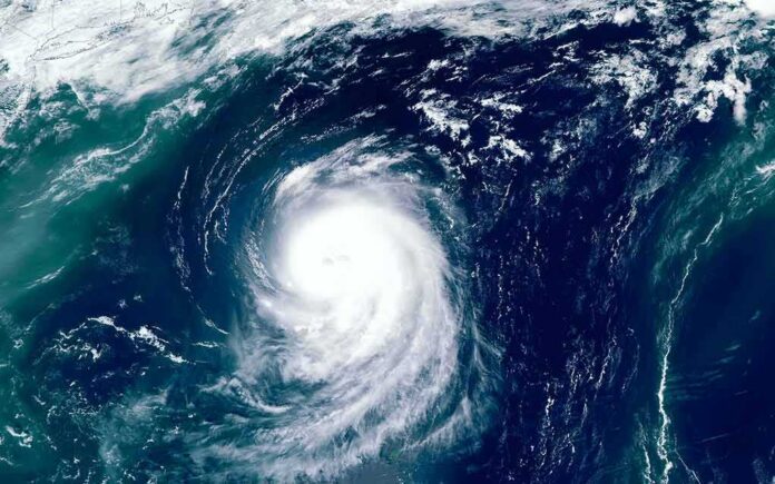
Typhoon Dujuan is barreling toward Tokyo during Japan’s Silver Week holiday, threatening floods, landslides, and travel chaos for millions of residents and tourists.
Story Snapshot
- The Japan Meteorological Agency warned of heavy rain, strong winds, and high waves across the Kanto region, the Izu Islands, and the Pacific coasts of Tokai and Tohoku.
- Dujuan strengthened into a typhoon with sustained winds near 30 meters per second and gusts up to 45 meters per second.
- Forecasters warned some areas could see up to 350 millimeters of rain in a single day.
- Hundreds of flights were canceled, and flooding already hit streets in Kamakura near Tokyo.
- The storm was expected to pass near the Kanto region’s Pacific coast from Sunday into Monday.
Storm Tracks Toward Tokyo During Holiday Week
Typhoon Dujuan, known in Japan as Typhoon No. 25, moved north over the western Pacific this week on a path toward the Kanto region, home to Tokyo and roughly 40 million people. The storm passed near the Ogasawara and Izu island chains before turning toward the mainland, arriving during Japan’s five-day Silver Week holiday when many families travel.
The Japan Meteorological Agency tracked the storm’s center about 170 kilometers south-southeast of Chichijima on September 18, moving west-northwest. By September 21, the agency reported Dujuan had strengthened again into a typhoon of Category 1 equivalent strength, with a central pressure around 975 hectopascals.
Heavy Rain and High Winds Threaten Eastern Japan
The Japan Meteorological Agency urged residents in the Izu Islands, Kanto, and Pacific coastal areas of Tokai and Tohoku to stay on high alert for torrential rain, violent winds, and high waves. Forecasters said up to 250 millimeters of rain could fall in the 24 hours through 6 a.m. Monday in the hardest-hit zones.
Rainfall totals climbed as the storm approached. The Tokai region could see up to 300 millimeters in a single day, while Kanto, Tohoku, and the Izu Islands could each get 200 millimeters. Some forecasts put peak totals as high as 350 millimeters, raising the risk of flooding and landslides in low-lying and mountainous areas alike.
Maximum sustained winds near the storm’s core reached about 30 meters per second, or 108 kilometers per hour, with gusts climbing to 45 meters per second. Those wind speeds are strong enough to damage buildings, snap tree branches, and make travel dangerous along the coast and on outer islands.
Flights Grounded, Streets Flooded as Storm Nears
Airlines canceled hundreds of flights as Dujuan closed in on the Tokyo area, disrupting travel for residents and visitors during one of Japan’s busiest holiday stretches. Waves crashed onto Hachijojima, a volcanic island south of Tokyo, well before the storm’s center reached the mainland, offering an early sign of the rough seas to come.
🚨🇯🇵 TYHOON DUJUAN HITS JAPAN
Powerful #Typhoon Dujuan is bringing torrential #rain and strong winds across eastern Japan, with Kamakura City among the areas under heavy-rain alerts.
🌧️ Flooding and landslide risks are rising as the storm approaches the #Tokyo region.… pic.twitter.com/CXHuIiw4Og
— World_Breaking_News03 (@Breaking2003) September 21, 2026
In Kamakura, a coastal city near Tokyo known for its beaches and temples, a river overflowed and sent floodwater up to knee level through parts of the town. Coastal areas of Chiba prefecture, near Shirahama, also reported torrential rain and roads becoming slick and dangerous as the storm drew closer.
Japan’s Layered Warning System Explains the Urgency
Japan’s typhoon alerts follow a set structure built to give residents as much notice as possible. The Japan Meteorological Agency issues five-day track forecasts first, then narrows to three-day forecasts, and moves to hourly updates once a storm nears the coast, a system built to reduce the chance people are caught off guard.
That layered approach means language in early bulletins often describes what could happen, not just what has happened. As Dujuan tracked closer to Kanto, the warnings sharpened from general caution to specific rainfall and wind numbers, reflecting how Japan’s forecasting system escalates alerts as a storm’s threat becomes more certain.
Sources:
youtube.com, stripes.com, accuweather.com, japantimes.co.jp, japan.stripes.com, nhk.or.jp, jwa.or.jp
© truetrendnews.com 2026. All rights reserved.